Lough Ouler Hike | Top hiking destination in the Wicklow Mountains
Tucked away, high in the Wicklow Mountains is a heart shaped lake waiting to be discovered. Lough Ouler is a special location with an epic view that seems too good to be true. But it is in fact, all real. Although it is not far from Dublin, this gem is an excellent escape for anyone interested in nature, relaxation and a bit of adventure. This Wicklow lake hike attracts nearly all types of hikers from seasoned walkers to day trippers.
Each step in this landscape continues to open up further and further revealing views that make each step absolutely worthwhile. It is remote enough away to feel special, yet close enough that you can enjoy the luxury of a weekend away. Lough Ouler is a wonderful place to engage with nature, be physically active, enjoy the outdoors and challenge yourself.
Quick Facts: Lough Ouler Hike Summary
| Feature | Details |
| Location | Below Tonelagee Mountain, Wicklow Mountains National Park |
| Lake Shape | Heart-shaped (best viewed from summit) |
| Height of Tonelagee | 817 metres (3rd highest in Wicklow) |
| Lake Elevation | Approx. 596 metres |
| Main Route | Tonelagee Summit (7 km / 2.5–3.5 hrs / Moderate) |
| Alternate Route | Glenmacnass Loop (10–12 km / 4–5.5 hrs / Moderate to Challenging) |
| Trail Type | Mountain trail, off-path, unmarked |
| Best Time to Visit | April to October (spring & autumn most scenic) |
| Views & Wildlife | Wicklow valleys, heather, deer, birds of prey |
| Public Transport | Limited – best with car or taxi from Glendalough |
What is Lough Ouler?
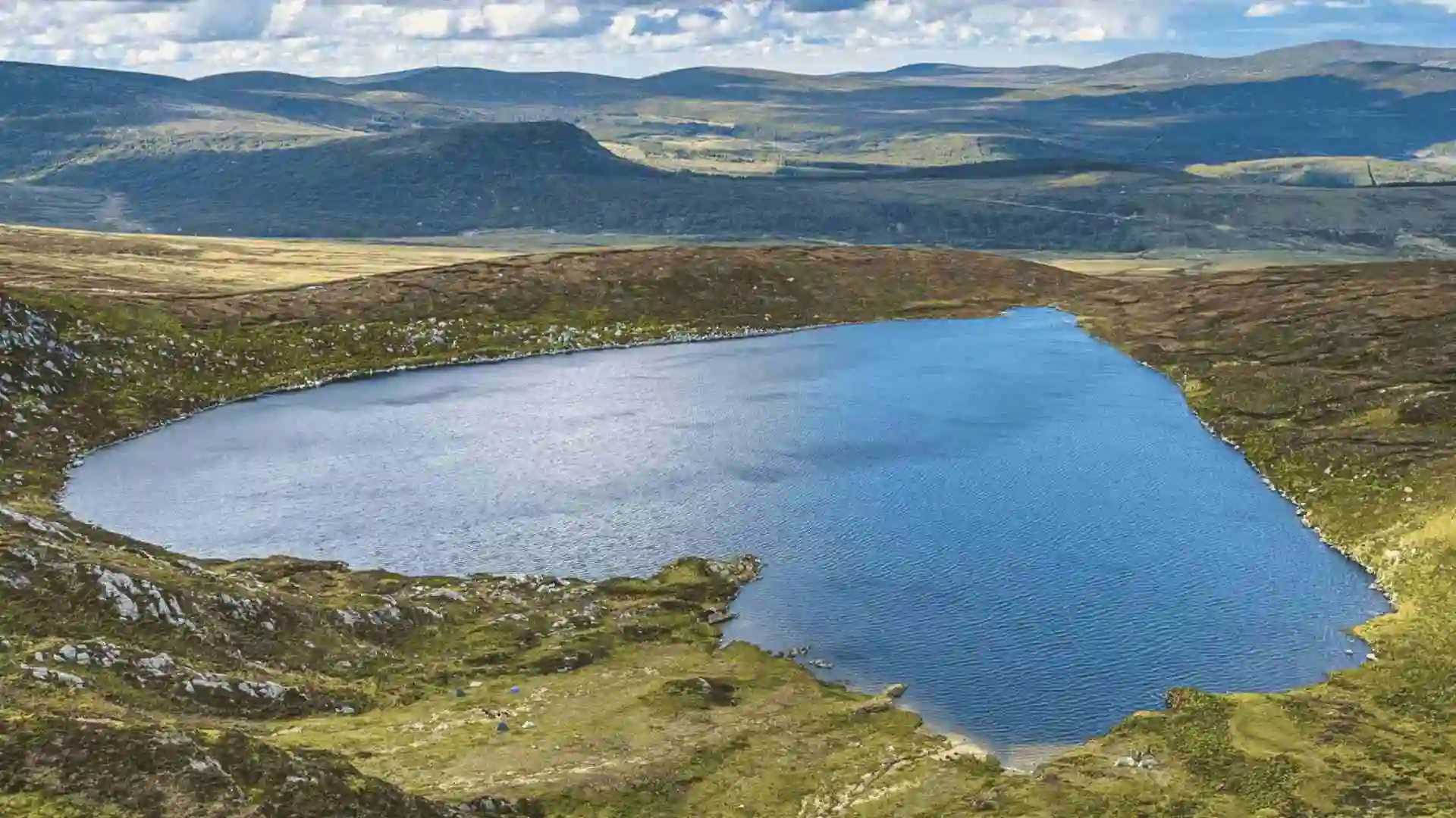
Lough Ouler is located below the slopes of Tonelagee, another of Wicklow’s highest peaks. This lake was formed thousands of years ago from glacial action and bagged its unique heart shape. Lough Ouler is set down into a corrie, a big hollow that has been scooped out during the Ice Age. The water is perfectly still, reflecting the surrounding slopes. Once viewed from above, it takes the shape of a heart. This heart lake Wicklow has quietly been branded a symbol of love, nature, and seclusion. The setting of Lough Ouler feels so untouched. Arriving at this destination marks the entrance into a secret part of the world.

Tonelagee itself has an overall height of 817 metres to make it the 3rd highest mountain in Wicklow. The name Tonelagee originates from the Irish “Tóin le Gaoith,” which means “backside to the wind.” This is certainly an appropriate name as a bracing breeze is usually encountered at the summit. Its height combined with the glacial hollow provides the ideal conditions for this lake to form in such a striking way. Hikers are often surprised by how perfectly heart-shaped this lake looks, especially on a bright sunny day when the edges of the lake are clearly pronounced in the sunlight.
Why hike to Lough Ouler?
Few places in Ireland are as picturesque or serene as this one. The moment hikers see the lake from above, it all makes sense. Its perfect shape and remote location ensure it qualifies as one of the country’s most romantic hidden treasures. Unlike the busy paths of Glendalough, the trail to this heart-shaped lake remains lightly travelled. There is no better place to get away from noise and people. Whether going with a partner, alone, or seeking landscape photos, this is calming and exhilarating. Plus, if you are on a quest to find the best hikes in Ireland, it is definitely worth the stop.

What makes this trail so great is how it masters a perfect balance of challenge and reward. The views of the surrounding valleys and peaks enhance the experience identifying perfect stops to catch your breath and soak it all in. It’s not a busy, well-known location, so the remoteness gives you real privacy you wouldn’t typically get in Rural Ireland. Wildlife watchers could see deer or birds of prey. There are also sections full of beautiful and colourful heather, moss, and wildflowers.
Route 1: Tonelagee Summit (Linear path)
The most common route to access the lake is by climbing up to Tonelagee summit. The starting point for the path is the Wicklow Mountains Viewing Point or nearby Turlough Hill. The path climbs steeply, roving through boggy and rocky ground. There’s not enough signage to guide this path but the path is well worn and followed by many other hikers who have experienced this route.
After you have made it to the summit the view welcomes you. Below you will see the heart shaped and still lake. The descent to the viewing point of the lake is steep, so be careful. This route is approximately 7 km long, and should take you around 3 hours to finish. This is the quickest route to the lake, and has great rewards with one of the best natural views around.

This trail is best suited for someone with some hiking experience and a reasonable degree of fitness. Another consideration is that this trail is exposed and open to rain. Also the wind can change conditions rapidly.
On dry days the views are superb, however, when in mist or fog conditions can quickly deteriorate. Although a demanding climb, the summit is a popular destination because it ends with a full view overlooking the lake. This is the angle that depicts the unmistakable heart shape outline of Lough Ouler. Oftentimes hikers will stop for a lunch or rest break at the summit before heading back down.
Route 2: Glenmacnass Waterfall Loop
Alternatively, if you are looking for a less busy route, this one begins from the Glenmacnass car park. This is a circular walk and will require crossing a river on your way. It traverses different terrain throughout the journey. Depending on your chosen terrain, the route has some steep and uneven ground, adding a bit more element of change. This route circles Tonelagee, taking a gradual incline until reaching the lake. The journey back offers the countryside perspective of the area. This route is best for anyone who prefers circular routes as well as enjoying the wider scenery of Wicklow. It will take 4 – 5 hours to complete, depending on your speed and the conditions.

Walkers will traverse forest and exposed upland moor through varying scenery making this route more varied than the direct ascent off Wicklow Gap. Of course, Glenmacnass Waterfall is a magnificent feature, particularly after rainfall, and is a nice added feature of the journey. More forgiving for hikers looking for a longer adventure full of landscape.

Lough Ouler hike difficulty comparison
| Feature | Route 1 | Route 2 |
| Distance | 7 km round trip | 10-12 km loop |
| Duration | 2.5-3.5 hours | 4-5.5 hours |
| Difficulty | Moderate | Moderate to challenging |
| Best for | Scenic photo ops, shorter hike | Adventures, loop lovers |
| Highlights | Tonelagee peak, heart view | Glenmacnass waterfall, solitude |
Getting there and parking
Getting to the start point is straightforward if you have a car. Wicklow Gap or Glenmacnass are about 1.5 hours’ drive on the road from Dublin. There is no real signage to follow for the trail, however, the main starting points would be the Wicklow Gap car park and Glenmacnass car park.
Public transport is an option, but you will have to put a little planning into the trip. You can catch bus 181 from Dublin to Glendalough, followed by a local taxi to the start. The parking at the start is limited, so leaving as early as possible is ideal. There are also no facilities at the start so you will have to make sure to bring all your gear, food and water with you.
Be careful on mountain roads and be especially careful in winter when difficult conditions may include fog or snow. It is best practice to check parking regulations and be cautious of blocking access to hiking trails or physical gate closures. A little extra time spent researching could use other hikers’ experiences. Some hikers will leave their car at the one end of a hike, then take a taxi to the start, depending on whether they’re traveling to start or end at a different point.
Trail difficulty and safety tips
The difficulty of the Lough Ouler walk varies, but each route involves steep off-trail terrain. There is no official signage or trail markers for either route, so you should consider downloading a map or navigation app. Navigation skills are crucial, as in the general surroundings of Tonelagee, mist can roll in very quickly and cut visibility. The heights of Wicklow are not the best place to test out your skills. So it is advisable to avoid walking in bad weather unless you are very experienced. Going solo hiking is not recommended unless you are confident and able with navigation. You should wear appropriate clothing and footwear. Good boots, gloves and layers as weather changes very quickly in mountains. Always tell someone your route and expected return time.

Navigation presents a significant challenge. Even experienced walkers have lost their way due to poor visibility. We recommend using a compass, GPS device, or a relevant map loaded on your phone. The cell signal is intermittent in the region, so you are better off to preload your data and information. If you are in doubt, turn around. You are rarely better off pushing on if you can’t see. If you have no visible landmarks or sense of direction, then it is best to return to safety.
What to bring?
- You will need a good pair of hiking shoes, with grip and support for the ankle.
- You should pack a waterproof jacket, some extra layers, and a hat as well.
- As for other gear, you will need a good amount of water and energy type snacks.
- If you are late, a head torch or flashlight is wise.
- A GPS device or offline map app for navigation helps eliminate wrong turns.
- A small first-aid kit is also a good safety addition too.
- The same goes for trekking poles to help maintain balance, especially downhill.
- It is a good idea to have your mobile phone battery fully charged before heading out. A small power bank can also be beneficial for longer walks.
- Sunscreen, insect repellent, and a whistle can also prove useful.
- Don’t forget to check the weather and make modifications to the gear after checking the weather.
Best Time to Visit
The best months to experience dry weather and clear skies are between Spring and early autumn. In the right light, the lake takes on a heart-shape when viewed from above, and for the best experience the sun should hit the water. Early mornings provide less people and softer light for the photographs. Autumn transforms the slopes with several golden tones, however summer has longer days. We suggest limiting your time on the trail in the winter because of snow and ice, only experienced hikers should try the walk with proper winter gear. Be sure to check the weather before you set off.
April to June is wildflower time and longer days. July and August are usually warmer but usually busier as well. October has cool air and beautiful colours in the bracken and trees. Visiting off-season can be peaceful, but there are greater risks, so be careful and plan well.
Nearby attractions and day trip ideas
After your hike, the area around the Sugar Loaf offers many more options. Glendalough is only a short drive away and is home to an old monastic site with trails and some beautiful scenery.
Glenmacnass Waterfall is a great place to have a short stop (or picnic) also with views. You can also experience the Military Road through the hills for amazing sight-seeing driving. Lough Tay and Lough Dan in the vicinity also offer walking trails and picnic spots. There are multiple options for B & B’s and eco-lodges to stay in Laragh and the surrounding Wicklow Mountains National Park. A trip to this area is a joy for a weekend of nature and fresh air.
Final thoughts
Lough Ouler is not just beautiful, it is a complete outdoor experience, from the first steps to the summit, it includes the climb, the view, the experience. It doesn’t matter if your goal is to get photos, get away from the hustle and bustle, get fit, or get fresh air, this heart shaped lake Ireland delivers. The Lough Ouler Wicklow hike offers its hidden gem to experienced walkers as well as the highly curious.
If you’re canvassing the best hikes to take this year, you must put Lough Ouler on the list. It’s not just about being there! It’s also about feeling accomplished and connected to the wild beauty of Ireland in an exceptional location. There are very few places of geological interest, great hiking and unique visual splendour that can have everything in one glorious location. No matter if you are a resident of Ireland living in Dublin, or a tourist to the Emerald isle, this is a walk that you will remember for a long time to come.


