Malin Head Donegal | The stunning Star Wars filming location in Ireland
County Donegal is Ireland’s most untamed, rugged, unspoiled corner of the Wild Atlantic Way, and its vast distances can sometimes bring the road-trippers a rude awakening.
Most travellers are looking for a cohesive plan that connects the enormous county-wide highlights with the dramatic ocean edge at Malin Head, and then, they get caught up in the wrong timing of the tides and are stuck having to back up down a single-lane mountain pass.
This article provides you the exact plan, with a wonderfully paced, safe route to the north of Ireland and a sensible micro-guide to lead you through this northernmost borderland like a native.
Key visitor information for Malin Head
This vulnerable promontory is struck full-stride by Atlantic systems, and the transition from clear weather to dense sea fog and gales can be drastic in as little as 15 minutes.
Cell phone coverage is often limited or lacking near the cliffs, making them hard to reach. When travelling in areas such as Buncrana or Carndonagh, make sure to pre-download offline navigation maps before you leave.
This is the best place in Ireland for seeing the Northern Lights, as it is a dark sky area with no light pollution. Before heading up the road at night, review geomagnetic activity indices and cloud cover forecasts.
The Malin Head Walk
For an authentic taste of the coastline, take the official 2.5 km long coastal trail loop (around 1 hour). This trail gently leads around Napoleonic military remnants, post-glacial geology and deep-sea chasms, all without any strenuous climbing.
Hiking boots must be sturdy and have good traction. When heavy Atlantic salt spray covers the natural gravel and grass trail, it becomes very slippery.
Top tourist attractions for you in Malin Head
1. Cafe Banba
Begin your journey at this family-style mobile coffee truck, situated right in the main viewing lot. Ireland’s most northern cafe, it’s a great warm, cosy place to enjoy a hot espresso or homemade pastry before heading out to face the wild sea winds.
2. Banba’s Crown
Follow the well-marked rocky ridge that is named after the mythical Celtic goddess of Ireland and walk a little up the hill. The highest point is marked with Lloyd’s Signal Tower, a stone British lookout tower constructed in 1805 to check for a possible French invasion.
3. The Eire sign
Please take a closer look at the ground just below the tower, where you will see the large white-washed letters reading EIRE 80. It was established in World War II to warn aircraft that they are flying over a neutral area.
4. Ballyhillin Beach and Inishtrahull Island
From the track look northeast and admire the distinctive raised beach at Ballyhillin, famous for its post-glacial gravel ridges worldwide. On sunny days, just beyond the white surf, look for Inishtrahull Island and its automated lighthouse that blinks on the horizon.

5. Hell’s Hole
Go along the coast, west, until you hear a deep rhythmic roaring rumbling from the ground. Hell’s Hole is a beautiful, thin ocean gorge through which the incoming Atlantic swell is driven into a deep hole of huge acoustic and hydraulic strength.
Safety Warning: DO NOT go past the safety barriers that have been marked at Hell’s Hole. The rocks are steep, plunge into the tumultuous sea and are perpetually damp, unstable and hazardous.
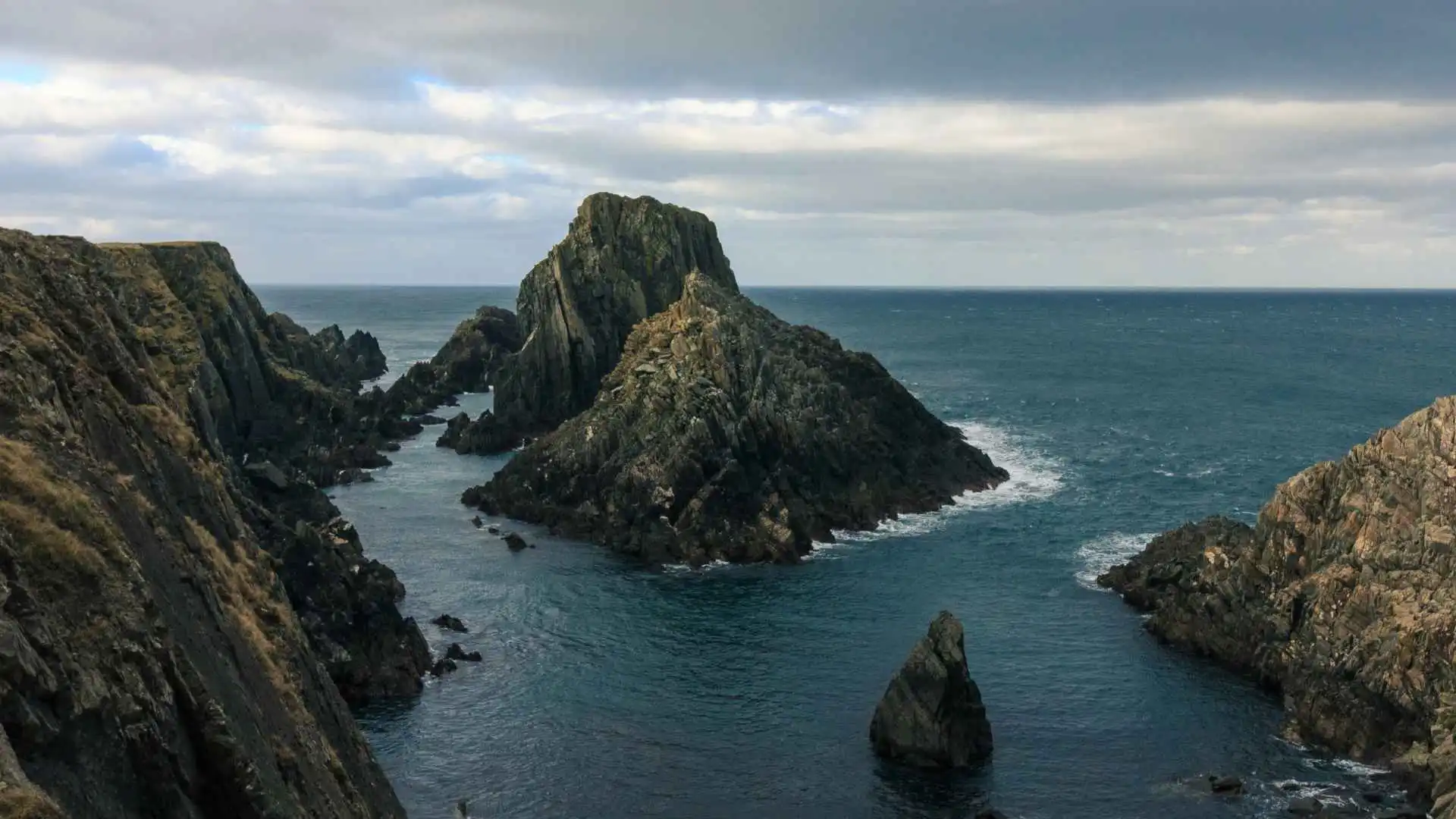
6. The Malin Head viewpoint
This panoramic viewpoint is at the north-western bend of the stroll. This is a rocky footing from which you can see the jagged “tooth-shaped” sea stacks reaching into the open ocean and, on days with high atmospheric visibility, even the Scottish Hebrides.
7. The history and the wildlife
In particular, this section of the headland is outstanding for the tracking of marine life. Monitor the deep water currents to look for basking sharks rising from the water, minke whales, harbour porpoises and resident grey seals hunting among the abundant nutrient-rich waters.
8. Farren’s Bar
End your northern journey with a visit to Ireland’s most northerly pub, which is a short drive along the approach road. This iconic pub is known for its traditional peat fires, and during the filming of Star Wars: The Last Jedi, it was the place where Mark Hamill and the film crew came to unwind after a long day’s filming.
What other things can you do nearby Malin Head?
From the northern tip you can explore all the key attractions of the surrounding Inishowen 100 route without having to spend too long in transit:
Five Finger Strand (15 mins south): An area with some of the steepest and spectacular sand dunes in Western Europe.

Doagh Famine Village (Nearby): An outdoor museum that brings to life the story of the Irish rural people who survived the 1840s Great Famine and continued to do so until the late 20th century.

Ballyliffin Golf Club (30 mins away): The 30-hole championship links course is set in a rugged coastal dune landscape.

Conclusion and summary checklist
Preparation for Donegal’s wild coast is essential. It cannot be rushed. You should plan your adventure in a sensible way around a geographic loop, and you’ll consult the local tide tables before visiting coastal caves or places where the waterfalls are hidden to make your journey safe and memorable along Ireland’s edge.
- Please refer to tide tables for Maghera and Hidden Waterfall.
- Print off maps offline prior to entering the Inishowen Peninsula.
- Bring sturdy hiking boots for the hike up and down the exposed hiking trails at the northern capes.


