Djouce Mountain | Hiking routes, tips and parking information
Djouce Mountain lies in the heart of the Wicklow Mountains. It stands at 725 metres and is one of the easiest summits in Ireland to access. It is close to Roundwood in County Wicklow. Both locals and tourists visit Djouce for its wide views, fresh air and natural beauty. The wooden boardwalk crossing its upper slopes helps protect the bogland and also provides a dry path, making it accessible all year.
The name Djouce comes from the Irish word Dioghais, which means “fortified height.” The name suits the mountain well as it feels like a high point overlooking the surrounding landscape. Djouce is part of Wicklow Mountains National Park and lies within the ancient geological spine of Ireland’s east coast. It is also part of the Dublin to Glenmalure military road, adding a historical aspect to your walk.
Quick Facts
| Feature | Details |
|---|---|
| Height | 725 metres |
| Location | County Wicklow, near Roundwood |
| Main Trailhead | JB Malone Car Park |
| Easiest Route | JB Malone boardwalk (6 km) |
| Hardest Route | Crone Woods Loop (14 km) |
| Hiking Time | 2 to 3 hours depending on route |
| Parking | Limited spaces at all car parks |
| Season | Spring to early autumn is ideal |
| Dog Friendly | Yes, but dogs must be kept on a lead |
Why hike Djouce Mountain?
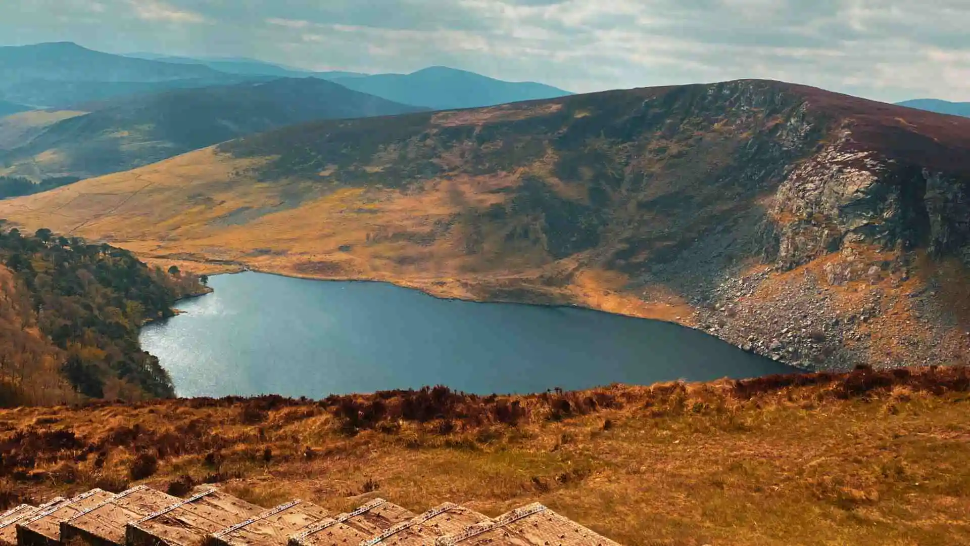
Few walks in Ireland offer such a mix of beauty and accessibility. The views over Lough Tay, also known as the Guinness Lake, are unforgettable. On a clear day, you can even see the Irish Sea and parts of Dublin. Djouce trails connect with the famous Wicklow Way, offering plenty of walking options. Car parks and trail markers make it easy to find your way.
The landscape features heathland, forest, and open mountain views. The Djouce walk suits all levels, from beginners to experienced hikers. Photographers will enjoy the wide skies, wooden boardwalk and changing colours of the land. In winter, expect snow and frost. In summer, wildflowers line the trails.

If you are looking for a peaceful and scenic hike not far from Dublin, Djouce is a great choice.
Trail routes and distances
Several hiking routes lead to the summit, making it one of the Best Hikes in Ireland. Each one differs in length, difficulty and scenery.
Choose based on your fitness, time and interest in either forest or ridge views.
1. JB Malone car park route
This is the easiest and most popular trail. It begins at the JB Malone Car Park, named after the founder of the Wicklow Way. The full route is about 6 kilometres return and takes around two to three hours. The boardwalk makes it beginner-friendly by keeping you off boggy ground. It is safe, clean and offers great views of Lough Tay along the way.
This trail is suitable for families, tourists or anyone looking for an enjoyable walk. The boardwalk helps protect the bog and keeps your feet dry. You can also connect to other parts of the Wicklow Way if you want a longer route.
2. Crone Woods loop
This trail begins in Crone Woods and is around 14 kilometres long. It includes more uphill walking and natural trail sections. Expect forested paths, streams and waterfalls. Views of Powerscourt Waterfall and Glencree Valley add to the experience.
The trail forms a loop and takes about four hours to complete. It is great for a full day out in nature and gives you a proper forest and mountain walk. Near the top, it joins the ridge path to Djouce for lovely views and a peaceful summit.
3. White Hill via Ballinastoe Woods
This route begins at Ballinastoe Woods and climbs over White Hill, a ridge shoulder of Djouce Mountain, with a total distance of about 12 kilometres. It takes between three to three and a half hours to finish. The trail includes forest, moorland and open ridge sections. The view over Lough Tay from this path is one of the best.
Ballinastoe Woods itself is worth seeing. The forest is thick and mossy with winding trails. The path becomes open and wild as you climb. It is often less busy and gives a feeling of solitude, which many hikers enjoy.

Trail route comparison table
| Route | Distance | Time | Difficulty | Elevation Gain | Key Features |
| JB Malone Car Park | 6 km | 2–3 hours | Easy | ~250 m | Boardwalk, lake views, summit |
| Crone Woods Loop | 14 km | 4 hours | Moderate | ~600–700 m | Waterfall, forest, glacial valley |
| White Hill Trail | 12 km | 3–3.5 hours | Moderate | ~500 m | Lake views, moorland, forest trail |
Trail difficulty and conditions
In general, the mountain’s difficulty ratings are between easy to moderate. The JB Malone route is all on lower elevating/flat ground and is the easiest. The Crone Woods and White Hill routes are steeper and have a variety of surfaces to cross. In the winter, the wind can be strong and icy and can make all trails difficult. The boardwalk will not break but it is wonky in places, and during rain or snow have found algae/sliming from December- March. The moorland sections are fully exposed so dress appropriately. There are plenty of trail markers throughout the mountain, although using a map or GPS tracker when there is poor visibility is particularly recommended. Having a trail map of the mountain is handy, especially off the main boardwalk.

The weather here can change very quickly, especially on this mountain. A bright sunny morning can quickly become foggy or wet from rain or mist. Bring a waterproof jacket and thick clothing. In summer, the wind on the ridge can be strong; so wear good boots, especially if you will frequently leave the boardwalk.
Parking and access considerations
Djouce mountain parking has varied routes. As for the JB Malone car park, this only has a small number of spaces. It also tends to fill up quickly on the weekends, particularly during sunnier months. The additional Crone Woods car parking option has slightly more spaces, but can be equally busy on sunnier weekends.
The Ballinastoe Woods car parking options again offer a smaller number of slots. Therefore, if you want to park, get there early. If you are going in wet conditions you will need to be careful on these narrow and steep roads. Public transport options to Djouce are limited, so most visitors arrive by car.

If you don’t have a car, it’s possible to put your bike on a bus to Roundwood, or walk from there. But, this adds additional time onto your walk. On sunny weekends, you will see crowds. Always lock your vehicle and take your valuables with you. If you are using GPS, make sure that you enter a specific car park name to avoid any confusion.
Highlights along the way
Djouce Mountain boardwalk is its main attraction. It runs over the bog and helps keep walkers safe to the summit. The view from the top is amazing. You can see Sugarloaf, Bray Head and the blue expanse of the Irish Sea. The JB Malone memorial marks the father of the Wicklow Way. You will also enjoy the small waterfalls, rocky outcrops and ancient woodland on the trail. Photographers and nature lovers will get plenty to enjoy.
Another lesser known highlight is the Glencree Peace & Reconciliation Centre but with a cafe to stop at. While walking, keep an eye out for stone cairns and way makers used by earlier generations. These touches of culture enhance the experience and help provide a sense of the land and its past.
Wildlife and landscape
The Djouce Mountain wildlife includes deer, grouse and songbirds, with the possibility of seeing some birds of prey.
In the summer, butterflies and many bees may be found. The terrain has heath, and gorse and mosses that develop through the seasons. The spring brings purple heather and bright gorse.
During autumn, the mountain has warm reds and bright golds. In winter the mountain has a snow covered peak, and ice still in the streams. It is a rich, living landscape shifting through the seasons.

The bogland adjacent to the mountain also hosts unique flora, such as sundew plants and cotton grass. Additionally, environmental campaigns and projects are beginning to have an impact in preserving the fragile balance in nature. You are walking through an ecosystem, so stick to the path.
Tips for a great hike
- Wear waterproof hiking boots
- Bring warm layers and rain gear
- Plan ahead to avoid parking issues
- Prepare yourself with plenty of water and snacks
- Use trekking poles in rough terrain
- Stay on marked trails
- Avoid hiking in foggy conditions
- Don’t forget to check the weather before you leave home
- Bring a phone or map
- Check for Djouce mountain routes ahead of time
- Download an offline trail map for your route or print out a copy
- If you are heading out on your own, let someone know your planned route
- Bring binoculars for birding
- Leave no trace
Nearby attractions and extensions
After the hike, take time to discover the area. The Powerscourt Estate and Gardens are also nearby, home to one of Ireland’s tallest waterfalls at 121 metres. The Sally Gap drive is amazing, offering great photo stops. If you want to immerse yourself in culture, check out Glendalough Monastic Site.
If you want longer walks, follow the Wicklow way into the hills. You can also have a quiet few moments at the viewing point for Lough Tay. Djouce and Lough Tay hike has a wonderful combination of history, nature, and peace.
If you’re willing to go the extra mile, the Military Road may be worth a stop. Built in the early 1800s, the road’s purpose was to help quell any rebellion from the Irish. There are stories all over, from folklore to natural wonder. A whole day spent in Wicklow can have it all: exploring, hiking and enjoying a nice meal in a nearby village like Laragh or Enniskerry.
Conclusion
Djouce Mountain is a hidden gem in County Wicklow, with an unmatched range of walks and views, you can’t go wrong with this hike no matter what your experience level is. The Boardwalk makes it accessible in almost any weather condition. Hike Djouce Mountain Wicklow and see the wild side of Irish beauty at its best. The mountain is a short drive (about 30 minutes) from Dublin, making an ideal destination for a weekend away or a day trip. So get your camera ready, put on your boots and pack your sense of adventure because Djouce Mountain is about to show you the nature of Ireland at its best.
FAQs
LATEST NEWS


