Glencoaghan Horseshoe Hiking Loop | Twelve Bens Connemara Guide
The Glencoaghan Horseshoe is one of the best ridge walks in Ireland. It lies in the heart of beautiful Connemara. This hike covers six peaks of the Twelve Bens. Hikers experience everything here a good hiking trip should offer. Rugged landscape, steep climbs and breathtaking views from each summit. The Glencoaghan loop offers both stunning beauty and real challenges.
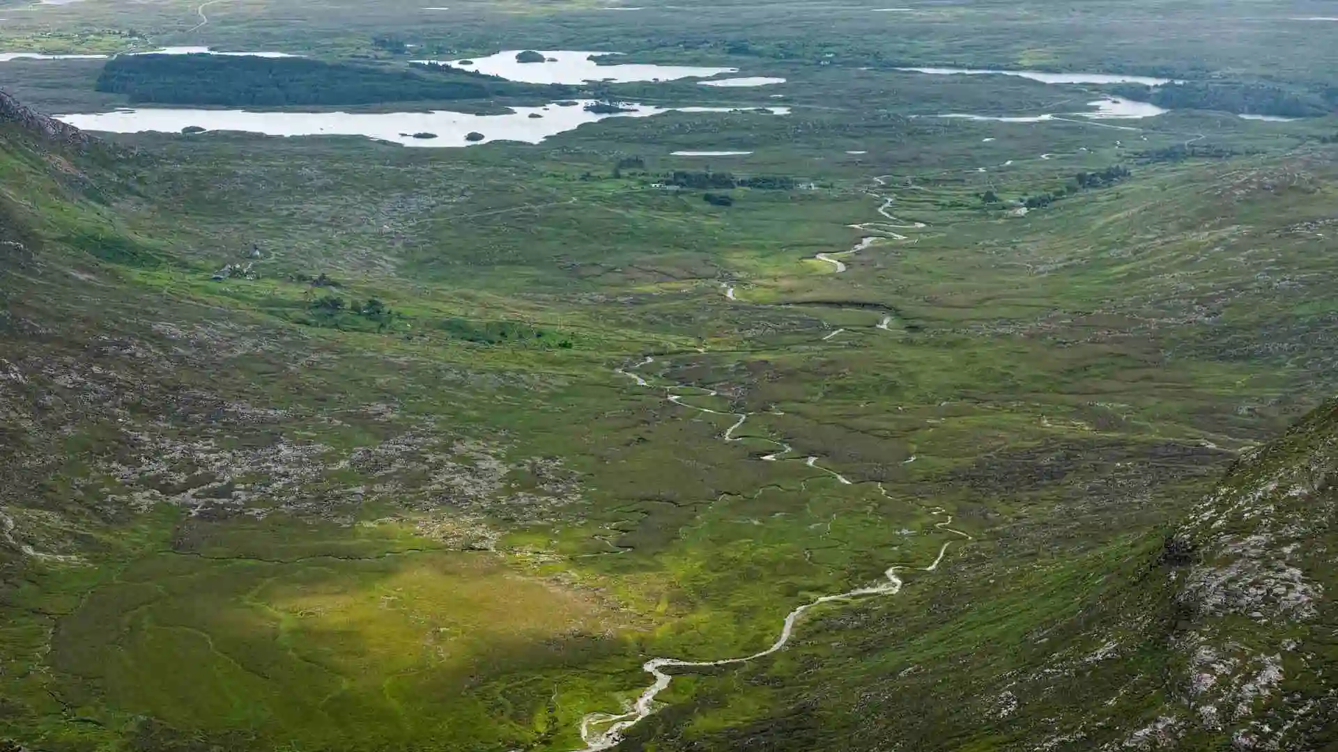
This hike features quartzite ridges and wide valleys with sweeping views of Connemara. Each summit rewards you with a fresh perspective of the mountains, lakes and coastlines.
For many, the Glencoaghan hiking loop is more than just a hike. It is a test of endurance, navigation skills, and mountain sense. Many regard completing it as a rite of passage. If you are looking for both challenges and scenery, the Glencoaghan hiking loop promises one of the finest adventures.
Hike Overview
The Glencoaghan Horseshoe is a circular Connemara hiking loop which includes six distinct peaks. Walkers start with Derryclare and continue on Bencorr, Bencollaghduff, Benbreen, Bengower and Benlettery . Together they form a classic mountain arc in the heart of the Twelve Bens.
Hikers can expect a mix of steep climbs, rocky ridges, and exposed scrambles. The rock on the peaks is predominantly quartzite, which feels wild and untamed. The sections of the trails can be slippery after rain, which adds to the technical challenge.

As you travel along the route the scenery is constantly changing. Every turn presents you with a new deep valley, glittering lakes, and far-off views to the Atlantic. This hike is demanding but makes it one of the most rewarding in Ireland due to its rugged nature. If you are fit enough to do it, you will have a wonderful experience in the mountains of Connemara.
Peak-by-Peak Breakdown
The Glencoaghan hiking loop is best understood by looking at each peak individually. Every summit adds its own terrain, challenge, and reward.
| Peak | Elevation | Key Features | Difficulty |
| Derryclare | 677 m | Steep start, valley views | Moderate–hard |
| Bencorr | 711 m | Sharp ridges, scrambling | Hard |
| Bencollaghduff | 696 m | Rocky ridge, exposed sections | Hard |
| Benbreen | 691 m | Long traverse, scree | Hard |
| Bengower | 664 m | Wide panoramas, rugged ridge | Moderate |
| Benlettery | 557 m | Final descent, easier finish | Moderate |
Peak overview table
1. Derryclare
The hike usually starts with Derryclare which climbs steeply from the valley floor. This climb is a bit of a slog but the views over Lough Inagh and Pine Island come in quickly. This first peak will set the tone for the entire loop.

2. Bencorr
Next comes Bencorr, which is characterised by narrow ridges and exciting scrambles. It is the most technical part of the loop. The quartzite rock here requires good footwork in wet conditions. This makes it a highlight for those who like scrambling Ireland. You will get a stupendous view when you reach the summit across the rugged heart of Connemara.

3. Bencollaghduff
Bencollaghduff offers rocky and exposed walking with more technical ridgeline walks. This summit presents the hiker with more significant uneven ridgeline and tricky descents. The scenery makes the efforts worthwhile with dramatic views stretching in every direction.

4. Benbreen
Benbreen is one of the longest traverses of the loop. The ridge has scree slopes and areas of loose rock that will test your balance. But it is rewarding with some of the best views of the hike.

5. Bengower
Bengower offers broad views, which is a favourite of many hikers. It is a rugged ridge, though easier than previous peaks. A great spot to take stock of the scale of the mountains of Connemara.
6. Benlettery
The last peak, Benlettery, allows for a long, slow descent back to the valley. Less demanding than the previous ones, but still requires some attention on the rocky ground. From here, the hikers return back to the starting point completing this dramatic loop.

Distance, Duration and Difficulty
Depending on your route taken, the Glencoaghan loop distance is approximately 14-17 kms. Most hikers take 8-9 hours overall. However, slower progress is common on the tougher terrains.
The hike involves an overall ascent of 1500- 1700 meters, making it one of the most challenging trails in Ireland. Each peak adds both ascent and descent, pushing you to your limits throughout the day.
The Glencoaghan Horseshoe difficulty is rated as challenging in terms of trail difficulty. It requires stamina, fitness and confidence with mountain navigation. The scrambling sections also require coordination and balance on rocky surfaces. For an experienced hiker, it is tough but doable, but for the inexperienced it may feel overwhelming.
Quick facts about the loop:
- Distance: 14–17 km
- Duration: 8–9 hours
- Elevation gain: 1,500–1,700 m
- Difficulty: Hard, requires experience
Trail Access and Starting Point
Most of the hikers start the Glencoaghan Horseshoe route in the vicinity of Benlettery Youth Hostel. This provides a natural start point plus a convenient parking area. Early arrival is recommended as spots are limited.

The trail follows the N59 that connects Galway and Clifden. The nearest towns for supply are Clifden and Recess, so these would be good options for accommodation.
Most walkers take the anti-clockwise direction, for convenience. You tackle the steepest climbs first, before enjoying an easier descent. This way you make natural progress along the ridge lines, avoiding doubling back.
Getting there is straightforward, but some careful planning creates a smoother start. Having a Glencoaghan trail map or GPS or printed route description is strongly recommended before setting off.
Weather and Safety Tips
Connemara is known for its unpredictable weather, and its clear skies can quickly change to fog, wind, or heavy rain. Therefore, preparation is key to a safe hike.
Be sure to have the safety kit, including a map, compass, and GPS, for navigation in poor visibility. Your kit should include sturdy boots, waterproof layers, spare food and water.
It is better to hike this rugged loop in pairs or as a group because it provides safety in case conditions worsen. Also, know your exit options, for example, know the paths leading into the valleys for emergencies.
A simple rule is to keep an eye on the official weather forecast and be prepared for all seasons in a single day. Because Connemara’s weather can always surprise you.
Highlights and Scenic Stops
The Glencoaghan hiking loop is abound with incredible features, each ridge and peak providing a new vista with reason to sit and enjoy.
One of the most commonly photographed locations is Pine Island, located near Derryclare Lough. The pine trees reflecting the mountains make for an ideal stop pre or post-hike.

The ridges themselves are the most exciting part. Narrow paths on the ridges with steep drops either side provide thrill-worthy experiences for those keen on adventure.
The ridge scrambling sections are physically demanding and add excitement to the journey.
Wildlife and flora also supplement the trail. Connemara is home to unique wildlife and occasional bird sightings. These little details enhance the charm of the hike.
Thing to Do After the Hike
At the end of a long day’s hiking many people look for food and comfort close by. Keane’s Pub in Maam is an easy stop off and serves filling food along with an abundant choice of drinks. That is certainly going to be a winter warmer after spending the day on the ridges, or hiking in cooler weather.

If you want to hang around the area a bit longer, Connemara National Park has plenty of walking trails and visitor options. You could certainly visit other peaks of the Twelve Bens, which offer various experiences in this dramatic environment. However you decide to approach your time here, the area has much to offer.
Conclusion
The Glencoaghan Horseshoe is much like an achievement. It is tough, demanding, and at times intimidating. Yet each step along the route rewards you with mesmerising scenery. This is a route for dedicated hikers looking for a serious challenge. Come prepared, bring the right gear, and respect the wild nature of Connemara. In return this Irish ridge walk will give you memories that last for a lifetime.


