Hike Lugnaquilla: Ireland’s Third Highest Mountain
Lugnaquilla proudly stands as the tallest peak in Leinster and the third-highest mountain in Ireland. This 925-metre peak is located in the beautiful Wicklow Mountains. It is very popular among hikers seeking a challenging yet rewarding experience.
The Fenton’s pub trail and the classic Lugnaquilla Glenmalure loop offer different adventurous experiences. No matter which route you choose, you are guaranteed to have an unforgettable experience. This Lugnaquilla hiking guide provides all the information you need to plan the perfect hikes.
Lugnaquilla Hike Quick Overview
| Detail | Info |
| Height | 925 metres (3rd highest in Ireland) |
| Location | Wicklow Mountains, County Wicklow |
| Popular Routes | Glenmalure Loop, Fenton’s Pub Trail, Art’s Lough |
| Difficulty | Moderate to Difficult |
| Best Time to Hike | May to September |
| Navigation Required | Yes – map, compass, or GPS |
| Military Firing Zone | Yes – Glen of Imaal route (check firing schedule) |
| Recommended OSI Map | Discovery Series Map No. 56 – View Map |
Location & Geological Significance
Lugnaquilla is located in the Wicklow Mountains. The deep valleys of Glenmalure and Glen of Imaal surround it. The mountain stands out owing to its flat and wide top. It is famously known as the Percy’s Table.
Lugnaquilla Fenton’s pub trail and the Glenmalure loops are some of the most famous routes hikers take. However, the fantastic views from the summit make the hike worth it. Geology suggests that the mountain is made of some of the oldest rocks in Ireland. It might have stood above the ice during the last ice age.
Scenic Hiking Routes
There are three main routes to the summit. Each has its unique features. Knowing the differences can help you make an appropriate selection.
Glenmalure Loop: Scenic and Challenging
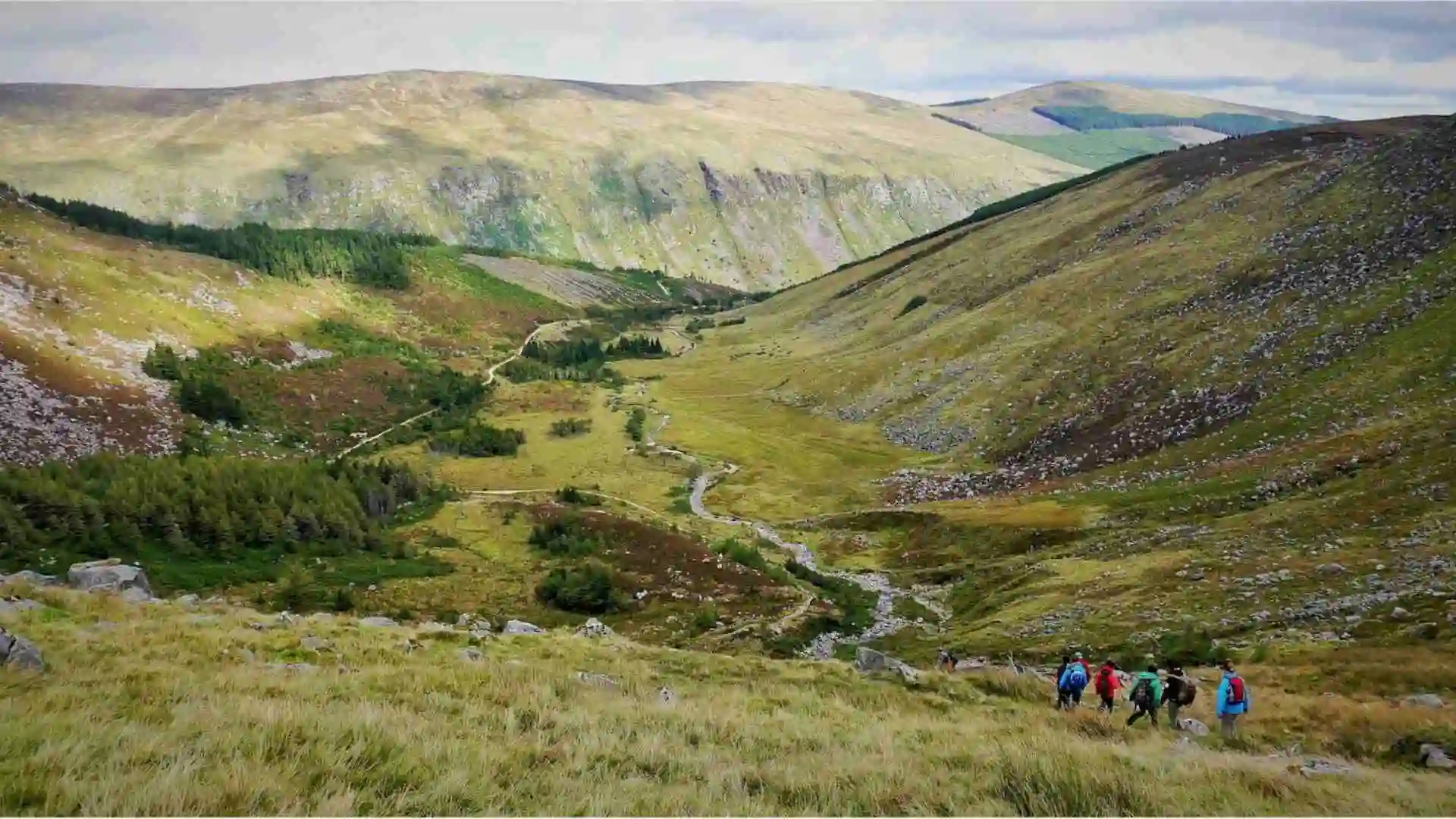
Starting from Baravore, the Lugnaquilla Glenmalure loop is famous for steep climbing and rocky terrain. This trail has variable conditions. Hence, it is crucial to possess both strong physical fitness and good navigation skills. The route offers breathtaking views, but it is best suited for experienced hikers.

Art’s Lough Route: Quiet and Moderate
This route also begins at Baravore. The smaller crowd here makes it quieter than at other places. It passes by the beautiful Lough Art as well.
Although the terrain includes some moderately complex steep slopes, this path is perfect for intermediate-level hikers. It is an ideal relaxing hike that also offers stunning views from the summit.

Fenton’s Pub Trail: Accessible but Cautious
This trail starting from Fenton’s Pub in the Glen of Imaal is the best option. It demands less physical exertion. However, caution is necessary concerning the Lugnaquilla military range warning.
The easier path has some difficult sections without marked routes on the summit plateau. Choose an appropriate time and proper Lugnaquilla safety gear for this route.
Glenmalure Loop via Fraughan Rock Glen

Starting from Baravore, this 15 km loop showcases waterfalls, Art’s Lough, and even glacial valleys. This hike is more challenging than Fenton’s Pub trail. However, it offers breathtaking Lugnaquilla summit views.
Because of the difficulty, the need for proper equipment is of utmost importance. The close vicinity to a military range demands good navigation skills. Hence, people often opt for guided hikes. If you love to hike, discover more best hikes in Ireland.
The Lugnaquilla hike route
Two prominent routes up Lugnaquilla provide different experiences. There is the Tourist Route, which starts from the Glen of Imaal, and the more isolated Aghavannagh & South Prison approach.
Tourist Route via Glen of Imaal
This option begins at Fenton’s Pub and follows a 13 km loop to the top of Camara Hill. Then, it takes 4-5 hours of walking to reach the summit.

The path passes through a military firing range, so be sure to check schedules and look out for any red flags. Poor weather can make navigation difficult. Hence, wear good boots and waterproof gear.
Aghavannagh & South Prison Route
This route takes around 6-7 hours to hike due to its longer length. Unlike other hikes, there are less defined paths as well as swamps and steep inclines.
Hikers must trek through the forest and the dramatic South Prison. Hence, hikers must have excellent navigational skills, fitness, and experience. It is most suitable for seasoned walkers or those in guided groups.

Lugnaquilla Hiking Difficulty & Safety Tips
Lugnaquilla can be challenging for beginners. Hence, you must come prepared, especially if you are a beginner.
Navigation
Often, fog covering the summit plateau trails makes the paths less visible. Hence, don’t rely solely on GPS. A map and compass will be a better option. If you are not confident in your navigation skills, consider joining a Lugnaquilla guided hike Ireland.
Weather
Dress appropriately with layers, waterproofs, and sturdy boots (please refrain from wearing jeans or runners. Expect sudden changes in conditions. It can be chilly and windy. The temperature can drop as low as -15°C.
Military Range
Glen of Imaal route traverses across a live firing range. Stay on the designated paths and be aware of scheduled firing times.
General Tips
Avoid heavy rains. If you must travel after, refrain from river crossings. Bring a fully charged phone along with food and water and hit the trails with friends. Remember to start early and bring a headlamp.
When to Go & Best Conditions
Here is some advice about scheduling your hiking at Lugnaquilla. If you follow these, you can enjoy a safe and smooth hiking adventure.
Best Time to Hike Lugnaquilla
To fully enjoy hiking Lugnaquilla, choose the time between May to September. The days are longer, and the weather is also good. Avoid going in the winter season.
Weather & Visibility
Critical checkpoints that need to be considered are not temperature alone. Visibility plays an important part. Always ensure that you carry both physical maps and guide apps.
Military Range Warning
Specific routes, such as the Glen of Imaal, need to be avoided. These go through active shooting ranges. Always take note of firing times and stay on clearly marked paths.
Essential Gear & Preparation
Preparing for a Lugnaquilla hike includes gearing up for the ever-changing weather and terrain conditions. This is a brief outline to help you out:
| Essentials | What For? |
| Footwear | Ankle-supporting hiking boots are a must. |
| Weather Gear | Waterproof jacket and pants, layered clothing underneath, a warm hat, gloves, scarf, and neck gaiter |
| Navigation | Keep a compass, along with a GPS as a backup. |
| Food & Water | Carry a stash of energy-filled treats and water for refreshment. |
What You’ll See from the Summit
From over 900 meters, hikers can enjoy breathtaking panoramic views, which include Wicklow Mountain National Park. On clear days, hikers can even catch views of Tonelagee and Mullaghcleevaun, the Great Sugar Loaf, and even Mount Leinster. Dublin’s skyline can also be seen surrounded by the green hills.
On clear days, Wales’s Snowdonia mountains can be spotted from a distance over the Irish Sea. The broad plateau on the summit also uncovers glacial features such as the North and South Prison cliffs. These magnificent views make it one of the best experiences for hikers.
Practical Details, Car Parks, Access Points
Before hiking Lugnaquilla, it is essential to know where to park and how to access each trailhead. Here’s a brief overview of the key starting points and a few Lugnaquilla navigation tips.
Access & Parking for Lugnaquilla
Choose your trailhead based on route and experience:
Baravore (Glenmalure)
Main start for the Glenmalure route. Free but busy on weekends. It is 90 minutes from Dublin.

Fenton’s Pub (Glen of Imaal)
The tourist route starts here. Limited parking; safest on weekends due to military range. It is 70 mins from Dublin Airport.

Aghavannagh
Remote access with limited roadside parking. Best for experienced hikers.

Driving & Navigation Tips
Be extra cautious when driving on the narrow roads of Wicklow, especially during rainy weather. Stick to reliable GPS options and bring a physical map as well as a compass.
Phones should not be your only navigation tool. Bring a physical map such as the OSI Map No. 56, available here. It includes Lugnaquilla’s summit, Glenmalure, and Glen of Imaal. Apps like OS Maps, Gaia GPS, and ViewRanger are good backups.
Nearby Attractions & Things to Do
Glenmalure is packed with natural beauty and historical sites. These can be an attractive addition to your Lugnaquilla hike. Let’s have a look at some great attractions to add to your itinerary.
Arts Lough & Glenmalure Loop
Arts Lough is a beautiful lake situated on the mountain. At 511m high, it offers peaceful waters and amazing scenic views. You can visit it through the 15 km Glenmalure Loop. On this track, you can pass the Fraughan Rock Glen and Cloghernagh Peak as well.
Glenmalure Valley
Glenmalure is a stunning glacial valley that offers rugged terrain and breathtaking trails. Hence, it attracts hikers planning to explore the Lugnaquilla Glenmalure loop.
Wicklow Way & Glenmacnass Waterfall
Wicklow Way hike Ireland is the country’s oldest long-distance trail. It still holds a unique spot in the country’s geographical map. Glenmacnass Waterfall is worth visiting, although it requires some time to reach. It is an ideal location for picnics, especially after rainfall.
History & Heritage
The Glenmalure Barracks and a memorial boulder honour the rebel leaders O’Byrne and Dwyer. The Battle of Glenmalure and the 1798 Rebellion are among the most fascinating historical events in the Glenmalure Valley.
Guided Hikes & Local Tour Operators
Many individuals choose guided hikes due to the rough landscapes and weather conditions. These ensure a safe hiking experience. A known provider is The Mountaintrails, prepared by Russ Mills. With specific skill sets, they offer customised hikes.
Another top provider is Hilltop Treks, based in Wicklow. They run small-group hikes with optional Dublin transport. Ian Taylor Trekking also specialises in personalised, small-group hikes.
Conclusion
Lugnaquilla is the hardest peak in the Wicklow Mountains. However, it gives the most excellent satisfaction after it’s been climbed. Regardless of the route you take, whether it’s the Glen of Imaal, Glenmalure, or Art’s Lough, you’ll enjoy breathtaking views and a great adventure.
Having an appropriate plan and taking all precautionary measures makes even the most challenging trails approachable and more enjoyable. You should first check the weather and military firing times before you plan to hike. Have a great time while soaking in the sights of Ireland’s third-tallest mountain!


