Mweelrea | The Irish mountain most tourists never climb
Picture yourself on a rocky outcrop, with the wild Atlantic Ocean plunging into the only glacial fjord in Ireland.
For the serious peak bagger looking for something off the beaten track, Mweelrea is the perfect Irish climbing opportunity to escape heavily manicured trails.
Both major routes are broken down in this article, along with a few hidden navigation hazards and necessary safety tips so that you can successfully conquer Connacht’s highest summit.
About Mweelrea Mountain
At an impressive height of 814 metres, Mweelrea is the highest point in County Mayo and the entire province of Connacht. This mountain is an absolute must-do for walkers who want to do Ireland’s 32 Peaks or the major county high points in Ireland.
The massif is surprisingly wild and untamed, as compared with the more touristy climbs. It is located on the coast, surrounded by the deep blue waters of Killary Fjord and the dark and striking waters of Doolough Pass.
Two main routes: Silverstrand vs Delphi Loop
While taking your steps up the highest mountains in Connacht, you will have to decide which of the two main routes, Silverstrand or the Delphi Loop, you will take. The eastern approach is a large technical mountain walk, while the western route is a mountain out-and-back trail.

How long does it take to hike Mweelrea?
The ascent is generally direct and straightforward using the west side of Silverstrand (Silverstrand Road) and is usually accomplished in 3 to 4.5 hours depending on the underfoot conditions.
The ground isn’t solid, so it can slow you down during the first stages of the trek. The entire Mweelrea Horseshoe hike from the eastern side of the Delphi valley can take 7-9 hours.
The steepness of the ascent and the complexity of the ridges are such that there is hardly any speed, and it is common to average one to two kilometres an hour on the more challenging climbs.
Where to start hiking Mweelrea Mayo?
For the West Coast Trail, head west from Louisburgh to Silverstrand Beach. Approximately 1 km before the open beach, it turns into a narrow cul-de-sac road that leads past a working farmyard.
There is a small gravel area at the end of the cul-de-sac for parking, and there are spaces to park approximately 4-5 vehicles on the farmer’s lane.
For the eastern horseshoe loop, park at the eco-trail car park at Delphi Resort or near the southern end of Doo Lough. This is the key location for gaining access to the mountain spurs inland.
Hiking Mweelrea from the Silverstrand Side
The western path starts along the concrete farmers lane, which passes the outbuildings until about 300 m, where there is a boundary farm gate. On the other side of the gate, you come straight onto the open hillside, which is all pathless, spongy ground.

Expect boggy, wet conditions to persist, from the first step. A barely visible path occasionally runs through the peat but often dips into deep and inaccessible marsh. To save your legs, head towards the right mountain stream.
As you make your ascent, you can find much firmer footing and a natural handrail along the stone-lined bed of the stream, walking parallel to it.
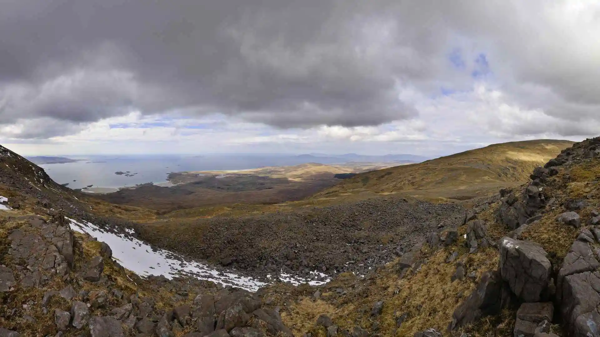
The summit and coastal panoramas
The last stretch uphill on the west side leads away from the soggy marshes into a steep, rocky shoulder ridge.
The slope gradually levels off and you’ll be walking along the edge of a magnificent high-level cliff with the glaciers below. The real summit is identified by a stone stack called the Mweelrea cairn, which is situated near the centre of the site.
On a clear day, the panoramic vistas are truly world-class with views of the Twelve Bens mountains and the sharp peak of Croagh Patrick, Ben Baun, and the islands that dot across the Atlantic Ocean.
What you need to know about the Mweelrea Loop
The eastern horseshoe is a high-quality, high-mountain expedition that surrounds a dramatic glacial bowl. It connects up the main peak with its formidable sister peaks, such as Ben Bury and the jagged tops of Ben Lugmore.
There are no waymarkers, signposts, or maintained paths on this looped walk. It is only recommended for fit hillwalkers who are completely comfortable with being exposed to the sun, steep descents, and high levels of exertion.
Climbing to Tawnynoran along the Mweelrea Loop
The first part of the loop starts outside the Delphi complex and heads along an old gravel boreen heading up towards the foot of the mountains. The easy flat walking abruptly ends as you turn onto the trackless Tawnynoran spur.
This first climb is a very difficult, steep walk through tall grass and soft, wet peat. Soft boggy walking is slow here, and you have to concentrate on your balance; eventually, you come to the broad ridge of rocks, which are easier to walk on.
Navigating the Ben Lugmore Ridge
After reaching the high ridgeline, the track heads west-southwest across the stunning Ben Lugmore Ridge. This is undoubtedly the most scenic part of the entire massif and is a serious mountain experience.
You are going to take a very thin trail, which hangs huge vertical drop-offs above your head. The left side is relatively flat and grassy, while the right side is sheer cliffs and dizzying steep drops, with absolute concentration and a good head for heights necessary.
Navigating through the clouds
The most worrisome feature of this massif is the extremely dynamic maritime microclimate. Peaks are exposed to frequent sudden heavy cloud cover within minutes, which can blanket the peaks with a dense mountain mist, significantly lowering visibility, due to their proximity to the ocean.

Avoid assuming that you will be able to find the small piles of stones or the occasional red spray paint markings left by previous hikers, as these can easily be missed in a total whiteout.
A solid ability to navigate is a must; you need to be an expert navigator and know how to use digital mapping applications that don’t require an internet connection to help you navigate and not walk on the edges of cliffs.
Finishing the Mweelrea Loop
Descending the sweeping, unfenced south slopes of the main peak, you will come down into the valley floor where the Owennagloch River flows. The ground continues to be uneven and uneven until you cross the bottom water channels.
The last leg of the route winds across a level, gravel forestry path. This easy walk back to Delphi Resort is a pleasant and simple way to end a monumental day in the Irish highlands.


