
Dublin Risk Areas for Deliveroo Riders: The Full Safety Map Explained (2026 Update)
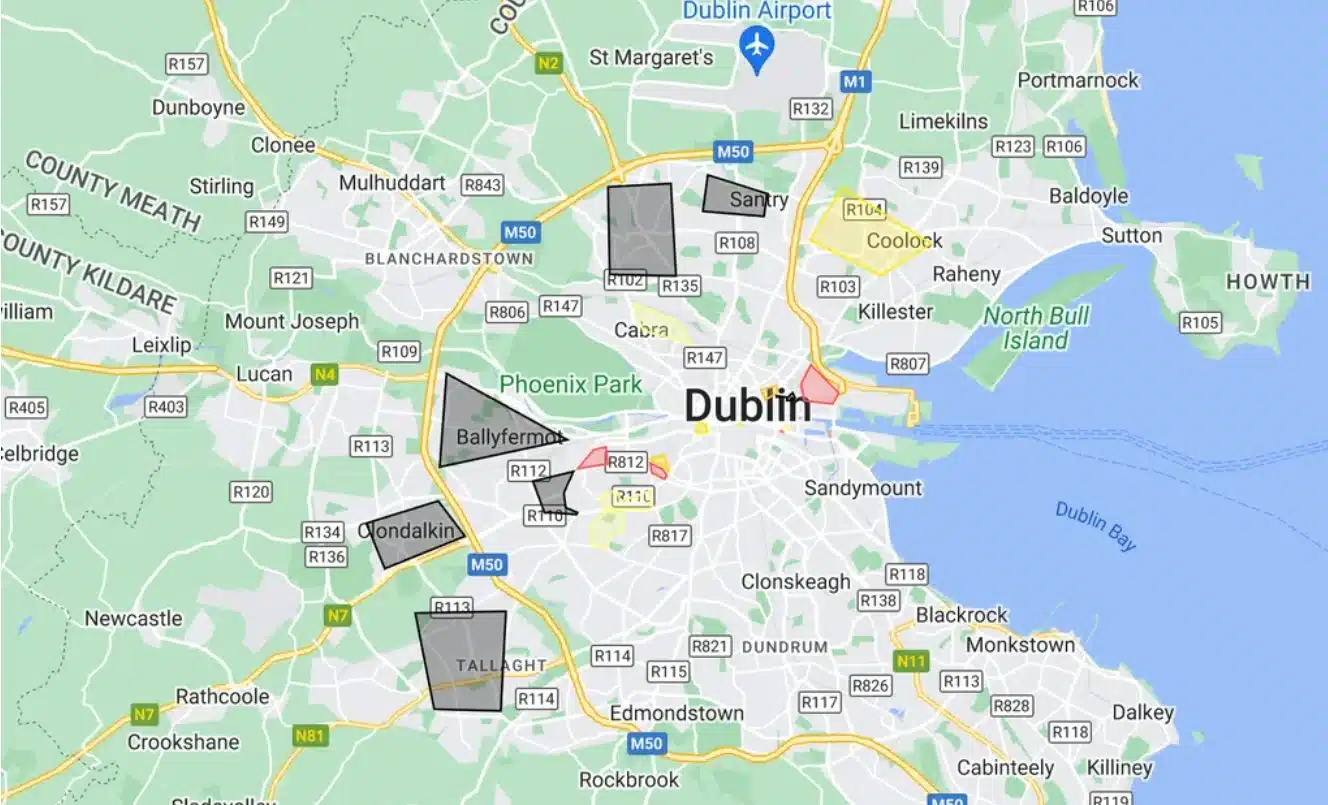
Deliveroo riders in Dublin have long relied on a rider made map called Áreas de Risco (Portuguese for Risk Areas) to flag the parts of the city where couriers have run into trouble. The map sorts 22 locations across Dublin into low, medium and high risk zones, with Finglas, Ballymun, Ballyfermot, Clondalkin, Tallaght, Sheriff Street and Bluebell named as the highest risk areas for riders. Below we break down every zone on the map, look at what the latest crime figures say, and share safety advice straight from riders and Deliveroo itself.
Quick Reference: Dublin Deliveroo Risk Areas
| Risk Level | Areas |
|---|---|
| High Risk | Finglas, Ballymun, Ballyfermot, Clondalkin, Tallaght, Sheriff Street and the surrounding streets, Bluebell |
| Medium Risk | Dolphins Barn (the section not listed as lower risk), East Wall, Inchicore, the area around Wowburger on Parnell Street, the area around the Tesco Express on Pearse Street, Ringsend flats |
| Lower Risk | Part of Dolphin’s Barn, apartments in Dublin 8, Cabra, Coolock and Beaumont, Pearse Flats, the area around Talbot Street, Crumlin, Crumlin 2, Temple Bar |
What Is the Dublin Deliveroo Risk Areas Map?
The Áreas de Risco map was first put together in 2021, reportedly by riders themselves rather than by Deliveroo. It emerged as couriers began comparing notes on where they had been targeted, at a time when riders were reporting a rise in assaults, robberies and bike thefts across the city. The map’s own description explains it plainly: it lists “risk areas described by couriers drivers, based on reported incidents and newspaper reports.”
The name itself is a clue as to who built it. A large share of Dublin’s delivery riders are Brazilian, and Portuguese remains one of the most commonly spoken languages among couriers working for Deliveroo, Uber Eats and Just Eat in the city. The map has resurfaced online several times since 2021, usually whenever a fresh incident involving a rider makes the news, and it continues to circulate among the courier community today as a rough, word of mouth guide rather than an official safety document.
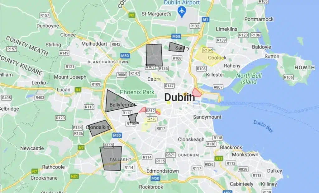
High Risk Areas for Deliveroo Riders in Dublin
The map’s highest risk category covers areas that riders have repeatedly flagged for serious incidents, including assaults and attempted bike theft. These are:
- Finglas, an area also referred to by some locals as having ongoing issues with drugs and anti social behaviour
- Ballymun
- Ballyfermot
- Clondalkin
- Tallaght, one of the largest Garda districts in Dublin by population
- Sheriff Street and the streets surrounding it
- Bluebell
Several of these overlap with areas that riders have separately named in press interviews as places they simply will not deliver to after dark. One Dublin based rider told a local news outlet that he avoids Ballymun and Cabra entirely because he knows he is likely to be targeted there.
Medium Risk Areas for Deliveroo Riders in Dublin
A second tier on the map covers areas categorised as carrying a moderate level of risk. These include:
- Dolphins Barn, excluding the specific pocket listed separately as lower risk
- East Wall
- Inchicore
- The area around Wowburger on Parnell Street
- The area around the Tesco Express on Pearse Street
- Ringsend flats
It’s worth noting that Pearse Street shows up twice on this list in different guises, and that’s not a coincidence. Separate Garda district level crime data has repeatedly ranked the Pearse Street district, which takes in Pearse Street itself, Westland Row, part of Temple Bar, Trinity College and the Docklands, as the district with the highest volume of recorded crime incidents in the country.
Lower Risk Areas for Deliveroo Riders in Dublin
The map’s lowest risk tier includes:
- Part of Dolphin’s Barn
- Apartments in Dublin 8
- Cabra
- Coolock and Beaumont
- Pearse Flats
- The area around Talbot Street
- Crumlin
- Crumlin 2
- Temple Bar
It’s tempting to read “lower risk” as “safe”, but that’s not quite the full picture. Temple Bar and the Talbot Street area both fall into this lower risk category on the rider map, yet both have been the scene of well publicised assaults on tourists in recent years, including an attack on a US visitor on Talbot Street in 2023 and separate incidents involving American tourists in Temple Bar the same year. A lower risk rating simply means fewer reported incidents against riders specifically, not that an area is free of crime altogether. Context matters just as much as the category label.
Why These Areas Keep Coming Up: What the Crime Figures Show
The rider map is based on anecdotal reports rather than official statistics, so it’s worth setting it alongside the Central Statistics Office’s own figures for a fuller picture.
Looking at the full year of 2025, homicide and related offences fell by 25 percent compared to 2024, burglary and related offences fell by 13 percent, and robbery, extortion and hijacking offences fell by 11 percent nationally, according to CSO figures released in March 2026. Robbery specifically has been falling faster in the Dublin Metropolitan Region than in almost any other part of the country over the past several quarters, dropping by between 13 and 16 percent depending on the quarter, with the steepest falls recorded in the region throughout 2025.
That said, the picture isn’t uniformly positive. The CSO’s most recent release, covering the year to Q1 2026 and published in June 2026, shows the total number of recorded victims of assault and related offences nationally rose by 4 percent, to 5,794, compared with the previous year, with female victims up 8 percent and male victims up 1 percent. So while property crimes such as robbery and burglary are trending downward, assault figures have not followed the same pattern, which lines up with what riders themselves have been reporting.
As for specific districts, Garda district data has consistently placed Pearse Street, Store Street (which covers O’Connell Street, Connolly Station, Talbot Street, Abbey Street and Amiens Street) and the Bridewell district (Smithfield, Stoneybatter, Capel Street and Church Street) among the highest volume crime areas in the city, all of which sit close to or within zones flagged on the rider map.
What Deliveroo Riders Are Actually Saying
Beyond the map itself, riders have been fairly consistent in their public accounts over the past few years. Recurring themes include:
- Rising reports of robbery and assault. Couriers interviewed by The Irish Times in early 2025 described the job as feeling more dangerous than it used to, with more frequent talk among riders of bikes being stolen and colleagues being attacked.
- Word of mouth warnings. Riders often rely on messaging groups to warn each other in real time about trouble in a particular street or estate, rather than waiting on any official alert.
- A possible ethnicity factor. Several riders, many of whom are migrants, have said they believe they are targeted partly because of where they are from as well as the job they do, with reports of xenophobic remarks accompanying some attacks.
- Riders declining risky orders. Deliveroo has advised couriers that they can decline to accept an order if they are uneasy about the delivery address, and riders have said they do exercise that option.
One Deliveroo rider became briefly well known across the country for reasons unrelated to the risk map. In November 2023, Brazilian courier Caio Benicio used his motorcycle helmet to stop a man who had attacked a woman and three children on Parnell Square. He was praised publicly as “a real Irish hero” by the then Taoiseach, a moment that also drew attention to how visible and exposed delivery riders are on Dublin’s streets, day and night.
What Deliveroo Is Doing to Improve Rider Safety
Deliveroo has said repeatedly that rider safety is a priority, and the company has taken a number of concrete steps over the past few years:
- Direct engagement with An Garda Síochána. Deliveroo has met with Gardaí and city councillors to raise riders’ repeated warnings about attacks and robberies, and has said it facilitates ongoing two way dialogue between riders and the force.
- Automatic accident and public liability insurance. All riders are covered as soon as they log into the app, including income support if they’re unable to work following an accident on the job.
- A partnership with the safety app Busby. The app lets riders alert others nearby if they need help, report hazards such as a blind turn or a pothole, and can detect a possible incident through a phone’s sensors, automatically contacting emergency contacts and Rider Support if the rider becomes unresponsive.
- Sick pay style cover for eligible riders. Riders working regularly with the platform may be able to claim daily payments if a doctor advises them not to work.
- Advice to decline risky deliveries. Riders are told they can turn down an order if they have safety concerns about the destination.
Some couriers have said publicly that safety measures such as personal alarms haven’t always reached everyone who was promised one, so it’s fair to say the picture is one of genuine effort alongside room for improvement.
Safety Tips for Deliveroo Riders Working in Dublin
Whether or not you ride in one of the areas flagged above, a few habits go a long way:
Save the number of your local Garda station alongside the national emergency line, so you’re not searching for it mid incident.
Trust your gut on the address. If a delivery location makes you uneasy, you’re entitled to decline the order.
Keep your bike, phone and delivery bag secured on your body, particularly in and around the high risk areas listed above.
Use a safety app such as Busby to report hazards and alert nearby riders if something goes wrong.
Stick to main roads and well lit streets after dark, and avoid quiet shortcuts through laneways or estates you don’t know well.
Where possible, travel in twos near known hotspots, especially in the evening.
Report every incident, even a minor one, both to Gardaí on 999 or 112 and to Deliveroo Rider Support, so a pattern can be tracked over time.
Seeking Transparency and Safety
The people behind the Áreas de Risco map remain anonymous, and its repeated reappearance online reflects an ongoing concern among riders rather than any official Deliveroo campaign. It isn’t an endorsed company resource, and Deliveroo has not commented on how accurate its categorisations are.
Even so, the map serves as a useful reminder of the real risks faced by delivery workers, and of the need for continued, open communication between platforms, riders and Gardaí to keep couriers safer on the road. For a full breakdown of the areas and the reasoning behind each category, the original map remains viewable on Google Maps.