Tonelagee Hike Guide: Best Routes & Stunning Viewpoints
Tonelagee is a well known mountain in the Wicklow Mountains, attracting hikers looking for scenic Irish landscapes. It is located in County Wicklow and offers one of the most rewarding summit experiences in Ireland. Many people hike Tonelagee because it overlooks the famous heart shaped lake called Lough Ouler. This unique lake shape makes the walk especially popular among photographers and outdoor enthusiasts visiting Wicklow.
The route suits beginners and experienced walkers looking for a short yet memorable mountain adventure. Tonelagee is widely considered one of the most accessible peaks with truly breathtaking summit views. Hikers also enjoy the peaceful surroundings and open landscapes found throughout the Wicklow Mountains region.
In this blog, we will explore Tonelagee and guide you through the best routes, stunning viewpoints, and tips to make your hike safe and memorable.
Where Is Tonelagee and Why Is It Famous
Tonelagee mountain is located in County Wicklow, in the heart of the Wicklow Mountains range. It reaches a height of 817 metres, making it the third highest peak in Wicklow. The name Tonelagee comes from Irish and means “backside to the wind”, reflecting its exposed summit conditions. Hikers know Tonelagee mainly for its incredible views over the famous Lough Ouler viewpoint. Lough Ouler is a naturally formed heart shaped lake, which is rare and visually striking in Ireland.

This unique feature makes the mountain especially popular among hikers, photographers, and nature lovers visiting County Wicklow. Despite its popularity, the area still feels peaceful compared with more crowded hiking destinations in Ireland.
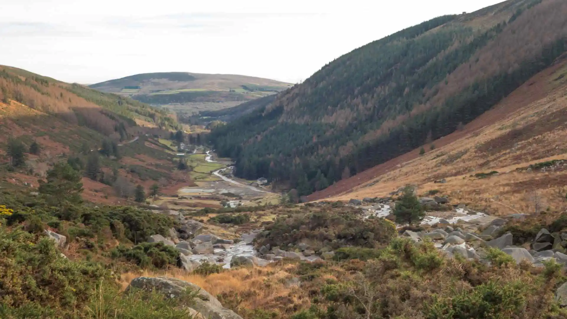
Best Tonelagee Route for Most Walkers
The most popular Tonelagee hike begins at the Turlough Hill car park near Wicklow Gap on the R756, where free parking is available for visitors. From the car park, hikers cross the road and follow a paved service road that steadily climbs towards the ESB Turlough Hill reservoir. The initial section is a continuous uphill walk, moderately steep but safe, making it manageable for beginners with basic fitness levels. As you continue, the path remains clear and easy to follow, with wide mountain views throughout the ascent.
The summit track is straightforward, though weather can change quickly, so visibility may drop near the top. For the best experience, continue beyond the main route towards a short extension leading to a cliffside viewpoint. This extra walk reveals the famous heart shaped Lough Ouler, a highlight of the Tonelagee route.
Beginners should expect a steady climb, a well defined path, and a rewarding but slightly challenging return walk.
Best Route for Beginners (Turlough Hill):
- Park at the Turlough Hill Car Park instead of the Glenmacnass Waterfall side for an easier start.
- Distance: Approximately 5km out-and-back.
- Time: Around 1.5 to 2 hours.
- Pros: More direct and slightly less demanding, though still a steep uphill walk.
Tips for Beginners:
- Wear waterproof hiking boots to handle muddy and boggy sections comfortably.
- Use hiking poles for better balance and support on uneven terrain.
- Do not rely only on phone signals; carry a map, compass, or offline GPS.
- Avoid hiking in heavy fog or cloud cover, as visibility can become very poor.
- Plan your hike in dry, clear weather, ideally from spring to autumn.
- Check trail conditions beforehand, especially after heavy rainfall, as paths can become dangerous.
Distance, Time and Elevation
The tonelagee walk distance ranges between 5 km and 8 km depending on the chosen route. Most hikers complete the hike duration within 1.5 to 3.5 hours, including summit and viewpoint stops. The total elevation gain is approximately 381 metres, with the steepest section at the beginning. This makes the hike relatively short but physically engaging, especially for those new to mountain walking.
How Difficult Is Tonelagee for Beginners
Tonelagee is considered a moderate mountain walk in Ireland, suitable for beginners with reasonable fitness levels. The initial climb is steep and can feel challenging, especially for those not used to uphill hiking. After this section, the terrain becomes more gradual, allowing walkers to recover while continuing towards the summit.
Weather conditions can make the hike more difficult, particularly because of strong winds and sudden cloud cover. There is little shelter on the mountain, so hikers are exposed to changing Wicklow weather. Overall, it is a good beginner hike in Wicklow if approached with preparation and awareness.

Here is a quick breakdown of the difficulty and what beginners should expect.
Steep incline: The ascent, especially from the Glenmacnass Waterfall side, is steep and often described as a short but intense climb. It can be physically demanding and puts pressure on both lungs and legs.
Boggy terrain: The trail is often wet and muddy, particularly in the early kilometres. Proper waterproof hiking boots and steady footing are essential.
Navigation challenges: The route is not always clearly defined, with sections crossing open mountain ground where the path can fade.
Weather exposure: At 817 metres, the summit is very exposed. Weather conditions can change quickly, with strong winds and sudden mist adding difficulty.
Best View of Lough Ouler on Tonelagee
The best view of Lough Ouler is not directly from the summit of Tonelagee. Hikers need to walk a few minutes beyond the summit towards a cliffside viewpoint facing the lake. From this position, the full heart shaped outline of the lake becomes clearly visible below. This viewpoint is one of the most iconic photography spots in the Wicklow Mountains.
Care is needed near the edge, especially during windy or foggy conditions. Reaching this spot completes the experience and makes the hike worthwhile for most visitors.
Best Time of Year to Hike Tonelagee
The best time to hike Tonelagee depends on the type of experience you are looking for, as each season offers something different. From long summer days with clear views to quieter autumn trails and more challenging winter conditions, the mountain changes throughout the year. Planning your hike according to the season can help you enjoy both the scenery and the journey more comfortably.
Best Time (May – August): This period usually offers the most reliable weather, extended daylight hours, and a higher chance of enjoying clear views of the famous heart-shaped Lough Ouler.
Spring (March – May): A great time for those who prefer peaceful trails, with fresh greenery and vibrant landscapes starting to bloom.
Autumn (September – October): Cooler temperatures make hiking more comfortable, and there are generally fewer people, though the ground can be wetter and slightly boggy.
Winter (November – February): The most demanding season, with the possibility of snow, strong winds, and low visibility, so proper preparation and navigation skills are essential.
Checking weather forecasts is essential, as conditions can change quickly in the Wicklow Mountains.
Parking, Access and Public Transport
The main access point for Tonelagee is the Turlough Hill car park in County Wicklow. This car park is spacious but slightly hidden, so drivers should follow directions carefully. From here, the trail begins just across the road, making the route easy to start.
Public transport is limited, and most hikers reach the area by car. Bus links serve nearby towns, but there is no direct regular public transport to the trailhead.
Safety Tips Before You Climb Tonelagee
Being aware of these factors and planning ahead is essential for a safe and enjoyable hike.
- Cloud cover can suddenly lower visibility, making navigation more difficult.
- Trails may become slippery after rain, so wearing proper footwear is important.
- There is no shelter on the mountain, leaving you exposed to wind and weather changes.
- Some parts of the trail are not clearly marked, so using a map or hiking app is recommended.
- Always check the weather forecast and avoid hiking in severe or unstable conditions.
Other Walks Near Tonelagee
Several great hikes near Tonelagee offer a mix of scenic views and varied difficulty levels across the Wicklow Mountains.
- Lugnaquilla: The highest mountain in Leinster, offering a challenging hike.
- Djouce Mountain: Known for its boardwalk trail and panoramic viewpoints, it is also part of the Wicklow Way.
- Glendalough Trails: A mix of valley walks and mountain routes suitable for all skill levels.
- Lough Ouler Loop: A shorter route focusing on the heart-shaped lake, usually accessed via Glenmacnass Waterfall car park.
- Mullaghcleevaun Loop: A challenging 16.5 km hike linking Tonelagee with Mullaghcleevaun, the second-highest peak in Wicklow.
- Scarr Mountain and Kanturk Loop: A moderate-to-difficult climb near Glenmacnass around Scarr Mountain with great views.
- The Spinc, Glendalough: A popular 9 km loop overlooking Glendalough’s Upper Lake and cliffs.
- Lough Bray (Eagles Crag): A short 5.5 km hike with dramatic views over Lough Bray.
- Maulin Mountain Loop: A 6 km walk near Djouce with views of Powerscourt Waterfall.
- Ballinastoe Woods Trail: An easier forest walk near Roundwood.
Is Tonelagee Worth It
Tonelagee is absolutely worth hiking for its unique views and relatively short but rewarding route. The highlight is the stunning view of Lough Ouler, one of Ireland’s most distinctive natural landmarks. When visibility is clear, the summit offers some of the best Wicklow mountain views available. It combines accessibility, scenery, and adventure, making it a top choice for hikers visiting Wicklow.
Because of its short distance and iconic viewpoint, Tonelagee often appears on lists of the best hikes in Ireland.
Conclusion
Tonelagee stands out as one of the most rewarding hikes in the Wicklow Mountains, offering a strong balance of accessibility and scenery. The real highlight is reaching the viewpoint where Lough Ouler reveals its iconic heart shape below. In clear weather, this hike delivers unforgettable views and remains one of the best mountain walks in Wicklow.


